


Planit
Photo Planner

Description of Planit: Photo Planner
এই নিখরচায় সংস্করণে, এপিমারিস বৈশিষ্ট্যটি একটি অ্যাপ্লিকেশন ক্রয়ের হিসাবে সরবরাহ করা হয়েছে। কেনার পরে, এটি প্রদত্ত প্ল্যানআইটি প্রো হিসাবে একই হবে। এখানে তালিকাভুক্ত কিছু স্ক্রিনশটগুলিতে এফিমেরিস বৈশিষ্ট্য সক্ষম রয়েছে। ফ্রি সংস্করণটি আসলে আপনি যা ভাবেন তার চেয়ে অনেক কিছু করতে পারে। এটি একটি পরিকল্পনা / মার্কার ফাইল রিডার, মানচিত্রে একটি ফোকাল দৈর্ঘ্যের প্রাক্কলনকারী, একটি ডওএফ এবং প্যানোরামা ক্যালকুলেটর এবং এমনকি আপনার ড্রোনটির জন্য বিমানের দৃশ্যটি পূর্বরূপ দেখতে পারে can এফেমারিস বৈশিষ্ট্যটি এতই সংহত হয়েছে যে এগুলির মধ্যে কয়েকটি বিনামূল্যে সংস্করণে সরবরাহ করা এবং বাকী অর্থের জন্য আপনাকে জিজ্ঞাসা করা আমাদের পক্ষে কঠিন। আমরা দেখতে পাচ্ছি যে কতজন ব্যবহারকারী আমাদের একটি স্টার রেটিং দেয় কেবল কারণ আমরা কোনও পরীক্ষার ব্যবস্থা করি নি। আমি মনে করি এটি ন্যায্য নয়। তবে যেমনটি আমরা বলেছি, যদিও আমরা কোনও পরীক্ষার ব্যবস্থা করিনি, দয়া করে এটি চেষ্টা করার জন্য বিনা দ্বিধায় অনুভব করুন। আপনার পছন্দ না হলে আমরা আপনাকে যে কোনও সময় রিফান্ড করতে পারি can
বাগ রিপোর্ট বা বৈশিষ্ট্য অনুরোধের জন্য দয়া করে info@planitphoto.com ইমেল করুন। আরও ভিডিও টিউটোরিয়ালের জন্য দয়া করে https://youtu.be/JFpSi1u0-is এ গিয়ে মনে রাখবেন। প্রতিটি ভিডিও কেবল কয়েক মিনিট স্থায়ী হয় তবে আপনি অবশ্যই এগুলি থেকে অনেক কিছু শিখবেন। আপনি ইনস্টাগ্রাম বা ফেসবুকের মাধ্যমে আমাদের কাছে পৌঁছাতে পারেন। লিঙ্কগুলি অ্যাপ্লিকেশনটির ভিতরে মেনুতে রয়েছে।
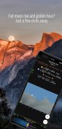
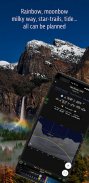
ল্যান্ডস্কেপ ফটোগ্রাফার, ট্র্যাভেল ফটোগ্রাফার, প্রকৃতি ফটোগ্রাফার এবং যারা নাইট ফটোগ্রাফি, সিটি ফটোগ্রাফি, সময়-গতি, স্টার-ট্রেইলস, মিল্কি ওয়ে বা অ্যাস্ট্রো-ফটোগ্রাফিতে আগ্রহী তাদের কাছে এটি বিশেষ কল: আর দেখার দরকার নেই, এটিই চূড়ান্ত অ্যাপ আপনার জন্য - প্ল্যানিট প্রো। এটি কেবল আপনার জন্য এক কাপ ফ্রেপ্পুচিনো খরচ করে তবে আপনি প্রচুর সময় এবং প্রচেষ্টা এবং প্রচুর গ্যাসের অর্থ সাশ্রয় করবেন। সর্বাধিক গুরুত্বপূর্ণ, এটি আপনাকে আরও বেশি ল্যান্ডস্কেপ ফটোগ্রাফি উপভোগ করবে।
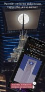
আনসেল অ্যাডামস তাঁর প্রথম বই "টাওস পুয়েব্লো" এর সূচনা দর্শনের জন্য উত্সর্গ করেছিলেন। তিনি "প্রিজিওলাইজেশন" ধারণাটি প্রবর্তন করেছিলেন, যা শট নেওয়ার আগে তার চূড়ান্ত প্রিন্টটি কী দেখতে চায় তা কল্পনা করার সাথে ফটোগ্রাফার জড়িত। অবশ্যই অনেকগুলি দুর্দান্ত ছবি রয়েছে যা তাড়াতাড়ি তোলা হয়েছিল। যাইহোক, ল্যান্ডস্কেপ ফটোগ্রাফারদের জন্য, সেখানে যাওয়ার আগে দৃশ্যটি দৃশ্যধারণ করতে সক্ষম হওয়া অপ্রত্যাশিতভাবে ধরা পড়ার সম্ভাবনাটি হ্রাস করবে এবং আরও ভাল শট পাওয়ার সম্ভাবনাটি ব্যাপকভাবে বৃদ্ধি করবে।
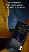
ফটোগ্রাফাররা দৃশ্যের প্রাক-চিত্রকল্পে তাদের সহায়তা করতে বিভিন্ন সরঞ্জাম ব্যবহার করেন। আজকাল, সেই সরঞ্জামগুলির মধ্যে অনেকগুলিই ফোন অ্যাপ্লিকেশন। প্ল্যানিট প্রো হ'ল একটি সর্ব-এক-সমাধান যা ম্যাপটি উপার্জনের জন্য এবং নকশাকৃত ভিউফাইন্ডার প্রযুক্তিগুলিকে গ্রাউন্ড সাবজেক্ট এবং সূর্য, দ্য আকাশের বস্তুগুলির সাথে একত্রে দৃশ্যের প্রাক-ভিজ্যুয়ালাইজ করার জন্য প্রয়োজনীয় সরঞ্জামগুলি সরবরাহ করার জন্য তৈরি করা হয়েছে the চাঁদ, তারা, স্টার-ট্রেইল এবং মিল্কিওয়ে।
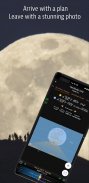
প্ল্যানিট প্রো অ্যাপ্লিকেশনটিতে, আমরা এটি জিপিএস স্থানাঙ্ক, উচ্চতা, দূরত্ব, উচ্চতা বৃদ্ধি, স্পষ্ট দর্শন, ফোকাল দৈর্ঘ্য, ক্ষেত্রের গভীরতা (ডিওএফ), হাইপোফোকাল দূরত্ব, প্যানোরামা এবং এরিয়াল ফটোগ্রাফির মতো বৈশিষ্ট্যগুলি দিয়েছি ed এফিমেরিস বৈশিষ্ট্য যেমন সূর্যোদয়, সূর্যাস্ত, চন্দ্রোদয়, চাঁদ ডুবে সময় এবং দিকনির্দেশ, গোধূলি সময়, দিনের বিশেষ ঘন্টা, সূর্য / চাঁদ সন্ধানকারী, বড় তারা, নক্ষত্র, নীহারিকা আজিমুথ এবং উচ্চতা কোণ, তারকা পথচলা পরিকল্পনা, সময় বিরাম গণনা এবং সিমুলেশন, সিক্যুয়েন্স ক্যালকুলেশন এবং সিমুলেশন, মিল্কি ওয়ে সন্ধান, সূর্যগ্রহণ এবং চন্দ্রগ্রহণ, এক্সপোজার / এনডি ফিল্টার ক্যালকুলেটর, হালকা মিটার, রংধনু অবস্থান পূর্বাভাস, জোয়ারের উচ্চতা এবং জোয়ার অনুসন্ধান ইত্যাদি সমস্ত তথ্য মানচিত্রে ওভারলে হিসাবে প্রতিনিধিত্ব করা হয় বা আপনার ক্যামেরার ভিউফাইন্ডারের মাধ্যমে যেমন দেখেন ঠিক তেমনই সিমুলেটেড ভিউফাইন্ডারগুলিতে (ভিআর, এআর, ছবি বা রাস্তার দৃশ্য) উপস্থাপন করা হয়। আপনার ল্যান্ডস্কেপ ফটোগ্রাফির জন্য যা কিছু আপনি চান না কেন এটি প্ল্যানিট প্রোতে রয়েছে।
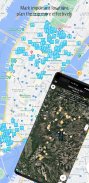
ল্যান্ডস্কেপ ফটোগ্রাফি প্রকৃতি বিশ্বের একটি দু: সাহসিক কাজ। আমরা কখনও কখনও বুঝতে পারি যে আপনি অন্বেষণের সময় কোনও নেটওয়ার্ক সংযোগ থাকবে না। প্ল্যানিট প্রো এটির মনে রাখার জন্য ডিজাইন করা হয়েছিল। আপনি যদি অফলাইনে উন্নত ফাইল এবং অফলাইন এমবটাইলস মানচিত্রগুলি প্রিললোড করেন তবে নেটওয়ার্ক সংযোগের প্রয়োজন ছাড়াই আপনি অ্যাপ্লিকেশনটিকে সম্পূর্ণ অফলাইনে ব্যবহার করতে পারেন।
Planit: Photo Planner - Version 10.8.7
(22-05-2025)
Planit: Photo Planner - APK Information
APK Version: 10.8.7Package: com.yingwen.photographertoolsLatest Version of Planit: Photo Planner
Other versions


Apps in the same category


You may also like...
 4.74.24.582.134.48


